New Scotland
Dispatch VII

A small park as we headed to the Canadian border out of Maine. (Photo by © Chip Walter)
We departed Machias, its revolutionary war history and blueberry pies, and continued following Highway 1 as it wound us toward Calais and the Canadian Border. The foliage was now in perfect bloom with red maples, golden birch, towering oaks berserk with color. Sometimes the trees clustered along still ponds and lakes, sometimes along the roiling Atlantic. Always the road wound left and right, up and down, like a wayward ribbon. We did this for a few hours until we rolled to the border crossing. With all of the work we had to do and apps we had to download; and all of the work finding a proper Canadian Test (something called a PCR test), I half expected to see a row of Royal Canadian Mountain Police with rifles ready to ensure we had all ducks in a row, or else. Yet only one car waited at the border. Ours. We had a nice chat with the female border guard, provided evidence of the COVID test, our passports and the special digital proof of vaccination (thankfully, Cyndy was all over this). Within five minutes we were driving through the town of St. Stephen into New Brunswick, one of Canada’s 10 provinces (and three territories).
We would eventually cover three of that nation’s provinces, but for now we were headed to the ferry that would take us to Digby, Nova Scotia, 50 miles across the Bay of Fundy and some of the most fickle water on earth. In all the world, no tide shifts more on any given day than the waters of the Bay of Fundy, making it one of North America’s Seven Wonders along with Niagara Falls, the Rocky Mountains and Grand Canyon. When the tide is out, you could walk along the mucky bottom of St. John’s harbor, assuming you had a mind to, but not very long afterwards you’d have to kayak to cover the same ground. Water sloshes in as if a gate has opened, and rises one foot every ten minutes until it’s breached 50 feet, taller than a three-story building. All the commotion is thanks to the pull of the moon, air currents and the spinning Coriolus Effect of the earth itself which make the planet’s waters splash back and forth as though they are rocking in a giant bathtub. The Bay of Fundy’s deep waters and unique funnel shape, do the rest of the job.

A body the size of Mars collides with ancient earth to form the moon. (Photo sklad500.ru)
(Sidebar: The moon was formed roughly 4 billion years ago when a Mars-sized body struck the ancient earth. That’s the theory. Afterwards, it cooled and spun into a tight circle around it’s mother planet. These days the moon is 250,000 miles away, but in those early days it was a mere 11,000 miles distant. If anyone had been around to see a full moon, it would have been a sight to behold, filling the entire horizon. If the moon still tugs at earth’s oceans now, you can imagine what it did then.)
Jim and Carl, the proprietors of Mahogany Manor, the B&B they have been running for over 20 years, provided us our accommodations for the evening. The house was big and beautifully appointed with Victorian furniture, an old clavichord and a “Harry Potter door” that once served as a place for private phone conversations when the first telephones came into use.
The next morning, after Carl provided an outstanding breakfast of fresh fruit, ham, yogurt and blueberry muffins, we headed for the ferry, but not before Jim regaled us with stories of the Blue Nose, a great Nova Scotian sailing ship built in the 1920s that never lost a race. (More on that soon.)
The evening before, the tide had been low, but now as we drove our car onto the Fortuna Rose, the harbor was flush with H2O, and the big ship, named for Rose Fortune, the daughter of runaway slaves and a successful business woman in Digby in the 19th century, took us across the bay to spectacular “New Scotland.”

Saying the Bay of Fundy and heading into “New Scotland.” (Photo by © Chip Walter)
We rolled off the Fortuna Rose and swung our car south and then east, continuing our habit of hugging the coastline. At some point, we decided we needed a physical map to get some perspective on the province. We stopped by a little town off Highway 1A, and searched three of the four stores that existed in the village and never found a map. “No one ever asks for them,” said the lady at the little market. “They use their phones.” Well, so do we, but we wanted to be able to put the map out on a desk or our bed and place ourselves more completely in the world. Before we found our B&B for the evening, we did finally locate an excellent map of Nova Scotia. With that in hand, we made it to YE OLDE ARGYLER LODGE, where we would bed down for the night, maps in hand. I never did get the origin of the Argyler’s name, but the place was beautiful; a snug, cozy room, excellent restaurant and a stunning view of the broad inlet at the shore which was dotted with pine-laden islands all around.

The view from Ye Olde Argyler (Photo by Chip Walter)
The next morning was rainy as we drove north toward Halifax. We’ve were told if we drove along the coast, we’d find the town of Lunenberg, a UNESCO World Heritage site chosen because it is considered a unique example of a classic British colonial town.
There’s a reason the town is considered British. When England won the French and Indian War, the town came under control of the redcoats. This part of the world, from northern Maine to Newfoundland was known as Arcadia and for centuries colonized by French citizens. During the struggle to take control of Arcadia, the British, at one point, deported thousands of French colonists in what is called the “Great Expulsion.” Over 11,000 of 14,000 colonists where sent packing, some of them to Spanish Louisiana (also formerly a French colony), where Acadians eventually became known as “Cajuns.”
Thousands died.
It seems the best things to come out of this horror was seafood gumbo, zydeco music and Henry Wadsworth Longfellow’s famous poem about it all, Evangeline..
There’s another reason Lunenberg (founded by a German fishing family), is famous. It was here that the great fishing and racing schooner Bluenose was built. There’s an exact replica in Lunenberg's harbor.
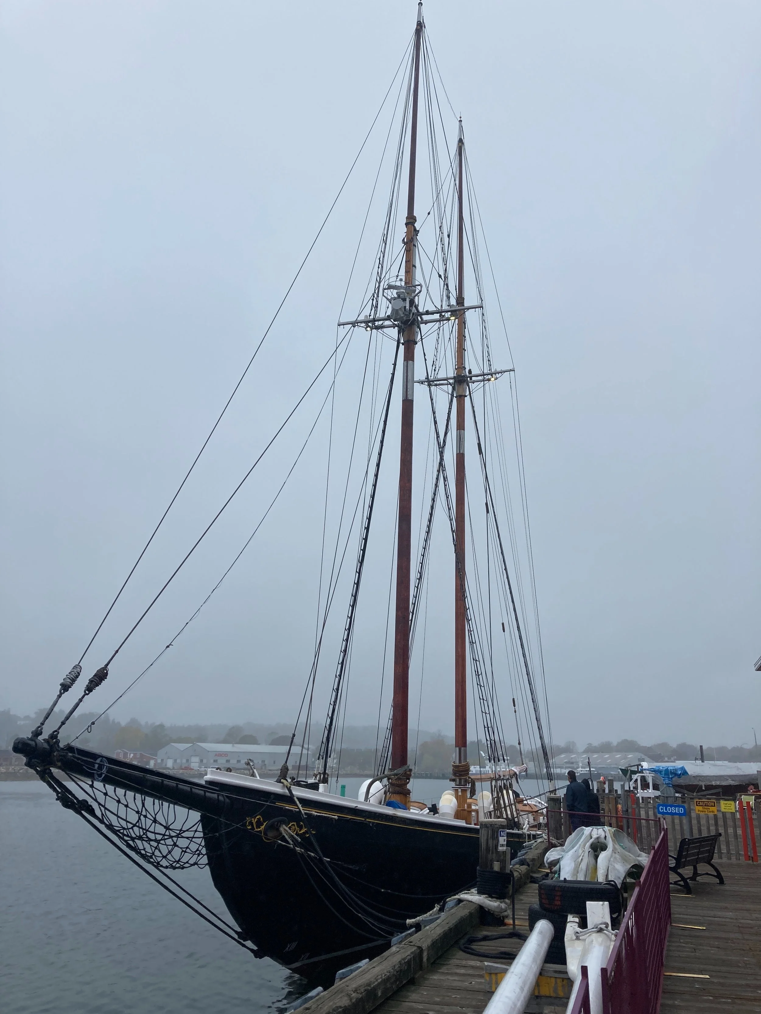
The famous Bluenose (II) - so ship every out-sailed it. (Photo by © Chip Walter)
She was built in 1921, and won or tied every race she ever ran until she was wrecked in 1946. Nova Scotians are immensely proud of this remarkable ship. She’s as revered in Nova Scotia’s sports pantheon as Babe Ruth, Mario Lemieux or WNBA’s Maya Moore. A replica of the Bluenose (an old name for a Nova Scotian resident - like Yinzer) was built in 1963 and reconstructed in Lunenberg in 2013 (that’s the one you see), the Bluenose II.
Before we headed to the tip of Nova Scotia and depart for Newfoundland, Cyn and I spent a day and a half at Peggy’s Cove, a small fishing village we had heard about along the coast famed for its wild beauty. We were not disappointed. Only 30 people actually live in Peggy’s Cove, but thousands now come to visit. The pictures make clear why.
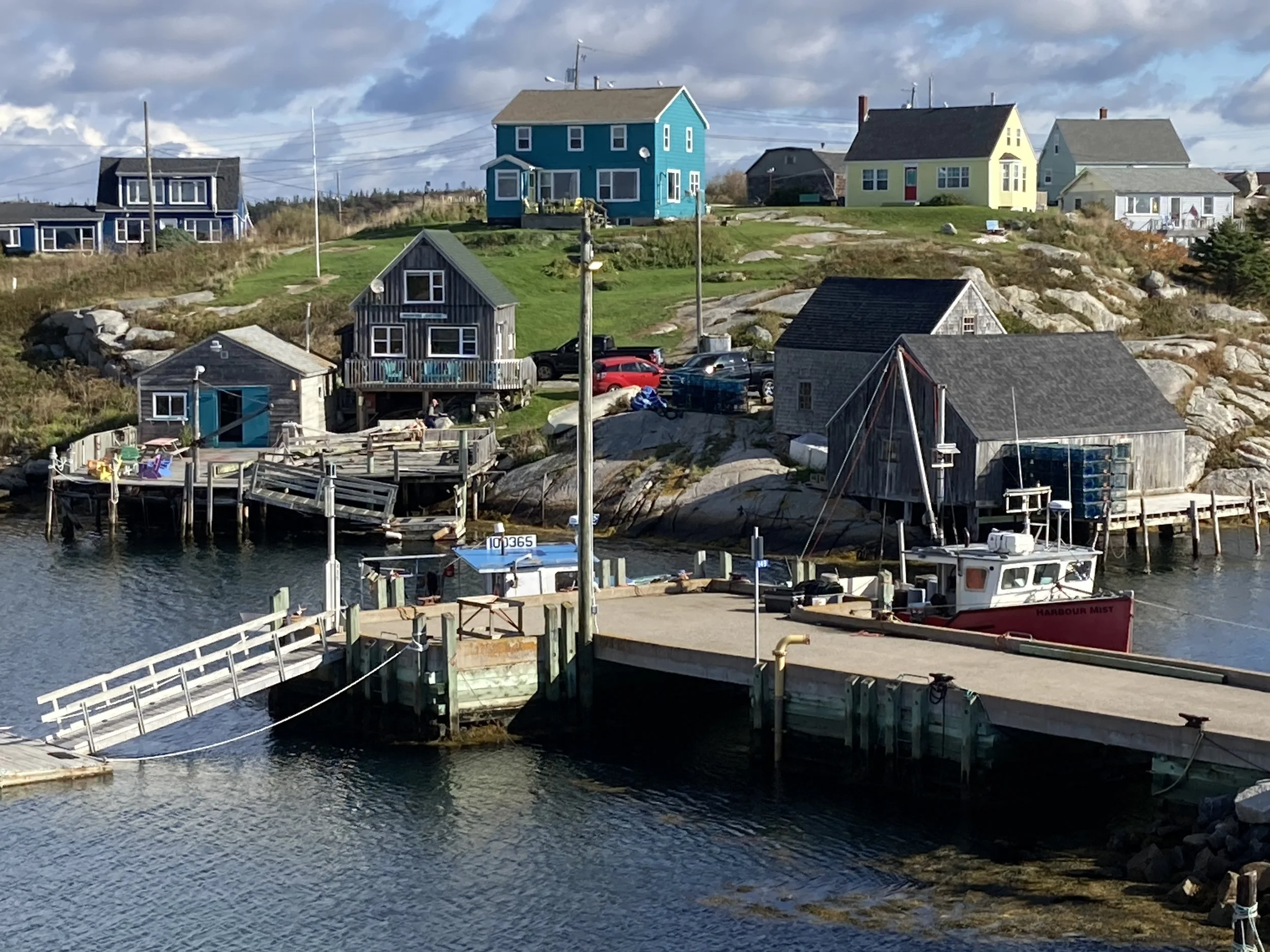

Peggy’s Cove Population 30 (Photos by © Chip Walter)

Peggy Cove's Famous Lighthouse and the Immovable Granite Rocks That Stand Upon It (Photo by © Chip Walter)
There are various stories about the name Peggy’s Cove, but my favorite is one told by local sculptor William deGarthe: In the 1800s a violent storm struck Halibut Rock off of the Cove’s Lighthouse Point. A schooner ran hard aground and the crashing waves destroyed the ship and all aboard except one little girl who was found alive on the shore. All she could tell the people who found her was that her name was Margaret, or Peggy for short. She was taken in by a local family and lived her entire life there. Since she had no last name, she was called Peggy of the Cove, and in time, the tiny village itself took on her name.
The cove is one of the most beautiful places I’ve ever seen, set in a deep inlet on the North Atlantic, protected by an enormous granite promontory created 380 million years ago when two ancient land masses — Meguma and Avalon — collided and created mountains much like the Himalayas and pushing up what would become the Appalachian Mountain Range. Peggy’s Cove is a remnant of that range, cooked into granite and eroded by wind, rain, sea and repeated glaciers to reveal the Cove.
In two days time, we saw every kind of weather from warm and sunny to bitter wind and crashing waves.

Ocean meets igneous rock. (Photo by © Chip Walter)
It was difficult to leave it behind. [Later you’ll be able to find more pictures of this remarkable part of the world when my new website’s gallery of pictures from around the world are updated. Right now, if you like, you can visit many pictures from six continents that I’ve taken at www.chipwalter.com/gallery including Scotland, Istanbul, the Orkney Islands, and some of the oldest art in the world, taken while researching my article for National Geographic magazine, “The First Artists.”]
This is a series about Cyndy and Chip’s Vagabond Adventure - our journey to explore all seven continents, all seven seas and 100+ countries by land and sea, but never by jet. COVID has forced us to begin in North America from the tip of Newfoundland to the toe of Baja. Not a bad start. Soon we'll be heading overseas. What will the world be like following a global pandemic? What people will we meet? What cultures, places, languages and music will broaden us? Are we being pulled apart or are we coming together? We’ll find out. Come along with us on our #vagabondadventure. And tell us what you know and what you have learned in the parts of the world where you live or have visited. Along the way, let’s make the world a better place.