
Explore the World in Maps and Moments
Infographics that bring the Vagabond Adventure journey to life — from deserts to glaciers, ancient cities to lost trails.
Explore the world in maps and moments.
These infographics capture the spirit and story of the Vagabond Adventure — what it is, where it goes, and why it exists. Each one translates part of the journey into a single, shareable visual: the philosophy behind the project, the routes we’ve driven and hiked, and the people and places that give the adventure life.
From the sands of Egypt to the glaciers of Patagonia, these graphics connect miles to meaning — one image, one idea, one expedition at a time.
How to Use These Infographics
Each graphic can be viewed full-screen or downloaded for personal travel planning. You’re welcome to share them with credit to Vagabond Adventure / Chip Walter and a link back to this page.
Click an infographic for fullscreen. Pinch and drag on mobile.
A Vagabond Adventure
This flagship infographic introduces the Vagabond Adventure mission — why it began, who’s traveling, and what we hope to discover along the way.
It outlines the goals of the expedition: to explore the planet overland, uncover how culture and curiosity intersect, and share those discoveries through stories, photos, and data.
You’ll also find ways to follow the journey in real time — across continents and channels — as the road unfolds from one extraordinary place to the next.
It’s both a visual roadmap and a statement of purpose: an open invitation to travel deeper, stay curious, and see what connects us all.
How to Follow the Vagabond Adventure:

Hiking to Choquequirao — Peru’s Lost City Trail
Deep in the Andes, a narrow path climbs 3,000 meters to the “sister city” of Machu Picchu. This infographic maps the route, elevation gains, campsites, and ruins along the 60-kilometer trek to Choquequirao — one of the most breathtaking and remote hikes in South America.
Read More about Choquequirao and Peru:

Riding the Navimag Ferry — Through Patagonia’s Fjords
Chile’s Navimag ferry sails through a maze of fjords, glaciers, and remote islands between Puerto Montt and Puerto Natales. This infographic shows the route, wildlife sightings, port stops, and the icy wonders of Patagonia’s inner channels — a journey that feels like the edge of the world.
Read more about traveling Patagonia:

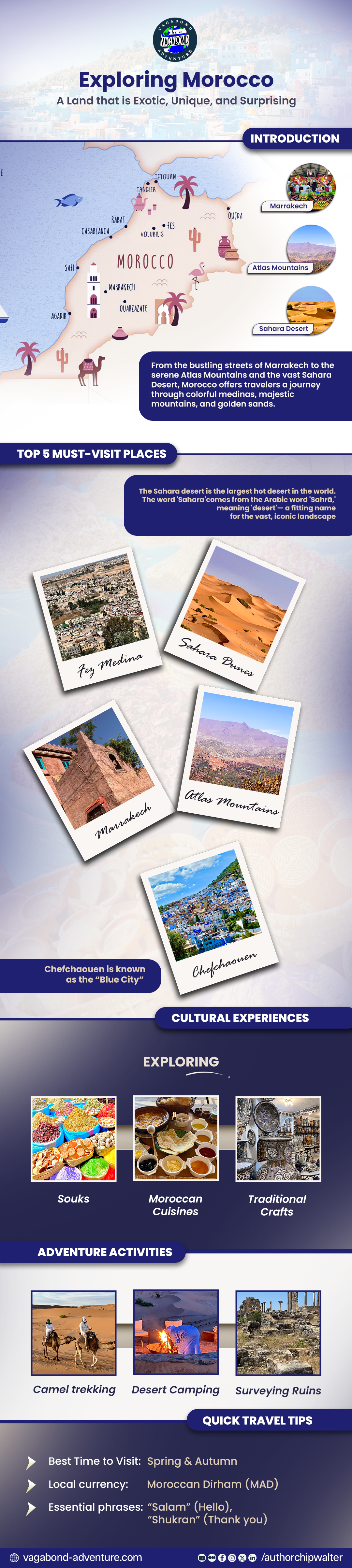
Touring Morocco - The Mysteries, the Exotic, and the Stunning.
Step into a land where ancient history breathes through the walls of millennia-old medinas and Roman ruins like Volubilis. Morocco is a mesmerizing fusion of Arab, Berber, and European influences, woven into a vibrant cultural tapestry of aromatic spices, intricate textiles, and hypnotic music. From the sun-drenched dunes of the Sahara to the bustling, labyrinthine souks of Marrakesh, it offers an exotic journey through time and tradition.
Read more about traveling Morocco:
More Visual Stories Coming Soon
The Vagabond Adventure continues. Future infographics will chart the most famous Christian pilgrimage in Europe, overland crossings through Morocco, treks into Viking North America, and a shaman led horse ride through Monument Valley.
Check back often — new maps are always on the horizon.